Oblivion:Blue Road
The UESPWiki – Your source for The Elder Scrolls since 1995
| This place page is currently being rechecked as part of the Oblivion Remastered Project. The page is being checked in several stages to verify any changes due to the release of Oblivion Remastered. All users are welcome to make changes to the page. If you make a change that is relevant to the project, please update this template accordingly, and make sure you have observed the project guidelines. Details Walkthrough: not written Interior Remastered Images: not added |
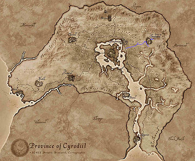
The Blue Road runs east to west between the Imperial City and Cheydinhal in the province of Cyrodiil. It connects with the Red Ring Road in the west and ends at Fort Farragut in the east.
Places of Interest[edit]
The following are places of interest along the way:
 Fort Urasek — A medium-sized fort east of the Imperial City containing goblins and marauders. (map)
 Roland Jenseric's Cabin — A building between the Imperial City and Cheydinhal (quest-related). (map)
 Barren Cave — A small cave west of Cheydinhal containing vampires and undead. (map)
 Knights of the Thorn Headquarters — A building west of Cheydinhal (quest-related). (map)
 Harlun's Watch — A village south of Cheydinhal (quest-related). (map)
- Cheydinhal — The main city in the Nibenay Basin region in northeastern Cyrodiil, dedicated to Arkay. (map)
 Fort Farragut — A small fort east of Cheydinhal containing undead (quest-related). (map)
